


Lake Tahoe Bathymetry Map
Made by
Print With Shapeways
 Choose Your Material
 Choose your color and finish
$287.51
Have a question about this product?
contact the designerYou must be logged in and verified to contact the designer.
Product Description
Interactive 3D View
If you would like a custom relief map, contact me through my website or through Shapeways.
Check out some photos of my other work here.
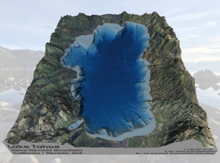
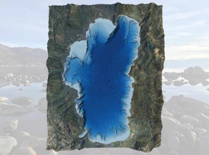
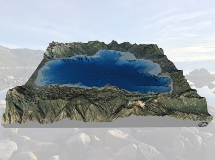
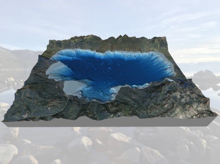
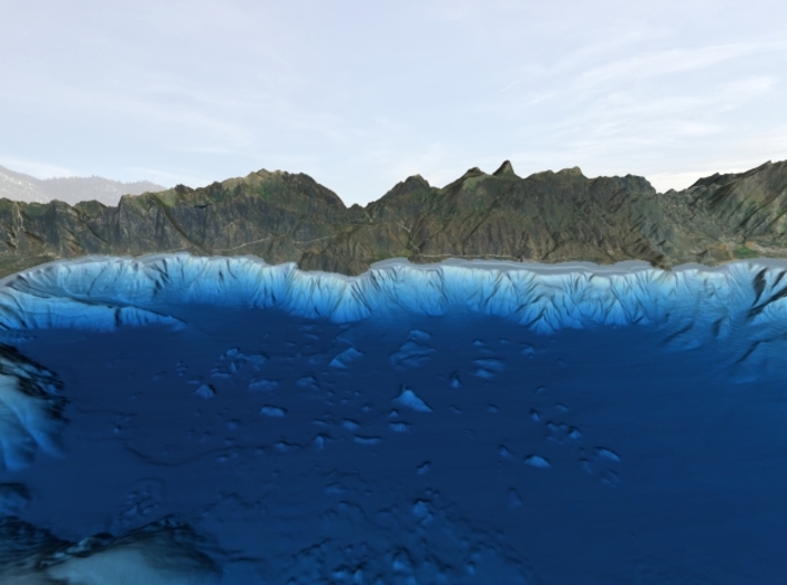
Lake Tahoe is a large freshwater lake in the Sierra Nevada of the United States. Lying at 6,225 ft (1,897 m), it straddles the state line between California and Nevada, west of Carson City. Lake Tahoe is the largest alpine lake in North America,[3] and at 122,160,280 acre⋅ft (150,682,490 dam3) trails only the five Great Lakes as the largest by volume in the United States. Its depth is 1,645 ft (501 m), making it the second deepest in the United States after Crater Lake in Oregon (1,945 ft (593 m)).[1]
The lake was formed about 2 million years ago as part of the Lake Tahoe Basin, with the modern extent being shaped during the ice ages. It is known for the clarity of its water and the panorama of surrounding mountains on all sides.[4] The area surrounding the lake is also referred to as Lake Tahoe, or simply Tahoe. More than 75% of the lake's watershed is national forest land, comprising the Lake Tahoe Basin Management Unit of the United States Forest Service.
Lake Tahoe is a major tourist attraction in both Nevada and California. It is home to winter sports, summer outdoor recreation, and scenery enjoyed throughout the year. Snow and ski resorts are a significant part of the area's economy and reputation.[5][6] The Nevada side also offers large casinos, with highways providing year-round access to the entire area.
Source: Wikipedia
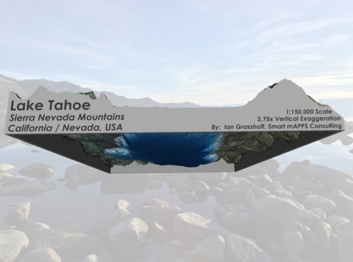
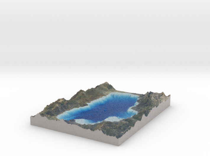
The model is created at a scale of 1:150,000 with 2.75x vertical exaggeration. It features a built-in base, so it sits perfectly on a desk or in a frame.
Model Data Sources: USDA (Imagery), USGS (Bathymetry, Elevation)
If you would like a custom relief map, contact me through my website or through Shapeways.
Check out some photos of my other work here.
Lake Tahoe is a large freshwater lake in the Sierra Nevada of the United States. Lying at 6,225 ft (1,897 m), it straddles the state line between California and Nevada, west of Carson City. Lake Tahoe is the largest alpine lake in North America,[3] and at 122,160,280 acre⋅ft (150,682,490 dam3) trails only the five Great Lakes as the largest by volume in the United States. Its depth is 1,645 ft (501 m), making it the second deepest in the United States after Crater Lake in Oregon (1,945 ft (593 m)).[1]
The lake was formed about 2 million years ago as part of the Lake Tahoe Basin, with the modern extent being shaped during the ice ages. It is known for the clarity of its water and the panorama of surrounding mountains on all sides.[4] The area surrounding the lake is also referred to as Lake Tahoe, or simply Tahoe. More than 75% of the lake's watershed is national forest land, comprising the Lake Tahoe Basin Management Unit of the United States Forest Service.
Lake Tahoe is a major tourist attraction in both Nevada and California. It is home to winter sports, summer outdoor recreation, and scenery enjoyed throughout the year. Snow and ski resorts are a significant part of the area's economy and reputation.[5][6] The Nevada side also offers large casinos, with highways providing year-round access to the entire area.
Source: Wikipedia
The model is created at a scale of 1:150,000 with 2.75x vertical exaggeration. It features a built-in base, so it sits perfectly on a desk or in a frame.
Model Data Sources: USDA (Imagery), USGS (Bathymetry, Elevation)
Request a custom order
and get this product personalized just for you
Details
What's in the box:
Tahoe-Bathy-8x10-150k

Dimensions:
Success Rate:
First To try.
What's this?
Rating:
Mature audiences only.


