Click and drag to rotate
Election 2016 Map 3d printed

DIGITAL PREVIEW
Not a Photo

Election 2016 Map 3d printed

DIGITAL PREVIEW
Not a Photo

Election 2016 Map 3d printed

DIGITAL PREVIEW
Not a Photo

Election 2016 Map

Not For Sale
QTY

Have a question about this product?

contact the designer
You must be logged in and verified to contact the designer.
Product Description
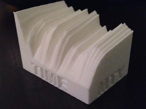
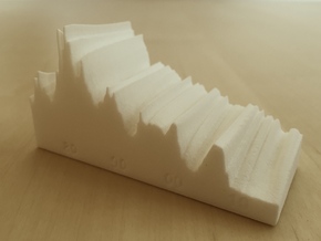
Map shows the increase in Republican vote share from 2012 to 2016, by county.  (Data are smoothed geographically for printability.)  Clearly shows increase in Trump vote share vs. Romney in the "rust belt" of MI, OH, PA, and WI which led his path to victory, as well as the drop in Republican vote share in Utah due to the "Evan McMullin effect."  
Details
What's in the box:
Election 01032016 Formatted1
Dimensions:
0 x 0 x 0 cm
Switch to inches
0 x 0 x 0 inches
Switch to cm
Success Rate:
First To try.
What's this?
Rating:
Mature audiences only.
Logo

Hello.

We're sorry to inform you that we no longer support this browser and can't confirm that everything will work as expected. For the best Shapeways experience, please use one of the following browsers:

Click anywhere outside this window to continue.