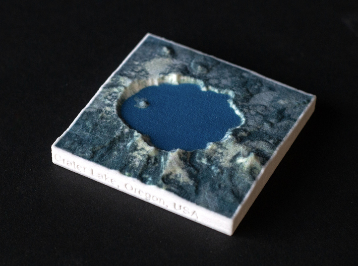


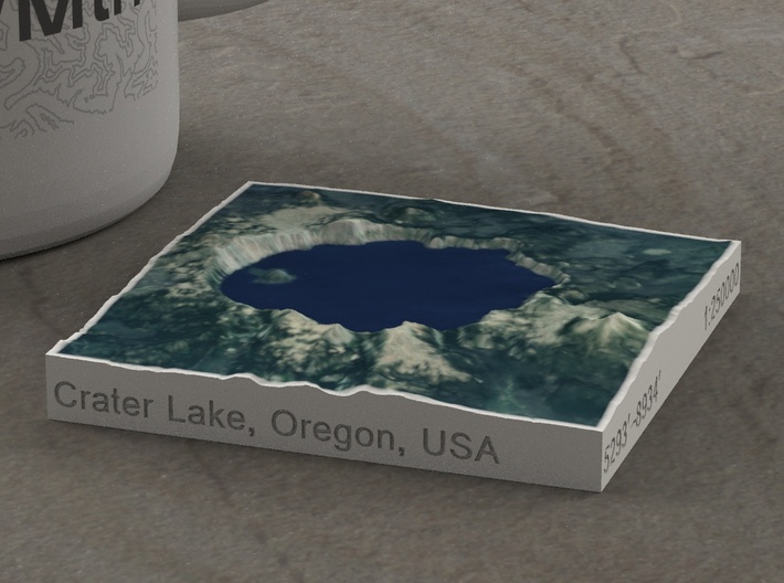


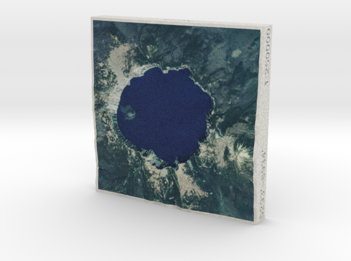
Crater Lake, Oregon, USA, 1:250000 Explorer
Made by
Print With Shapeways
 Choose Your Material
 Choose your color and finish
$35.00
Have a question about this product?
contact the designerYou must be logged in and verified to contact the designer.
Product Description
We could have called this model Mt. Mazama if it hadn't blown a mile off its top in a series of eruptions 6-8000 years ago. But it did, and now we have Crater Lake, filling the resulting 5 by 6 mile caldera. It is the deepest lake in the USA and second-deepest in North America (Great Slave Lake in the Northwest Territories is slightly deeper, though much larger), and the deep dark blue waters are some of the clearest in the country. The 33 mile Rim Drive was first built in 1919, is on the National Register of Historic Places, and is arguably one of the most beautiful roads in the USA.
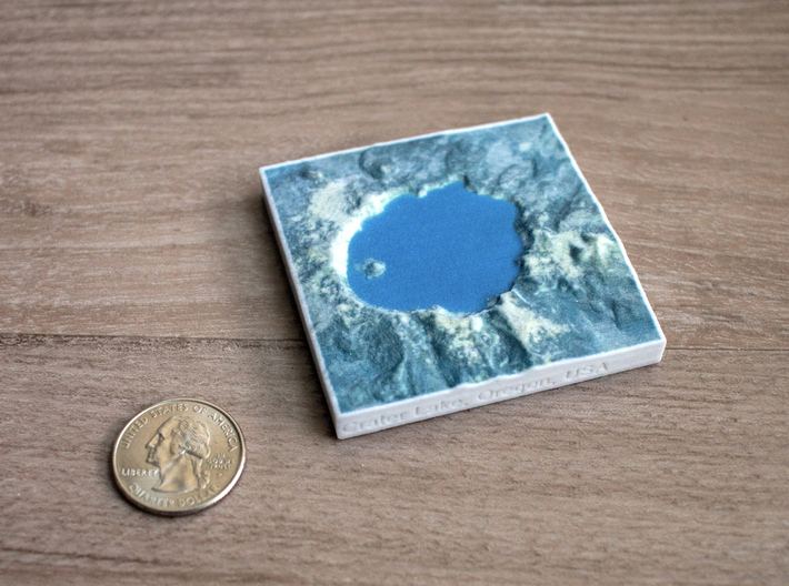
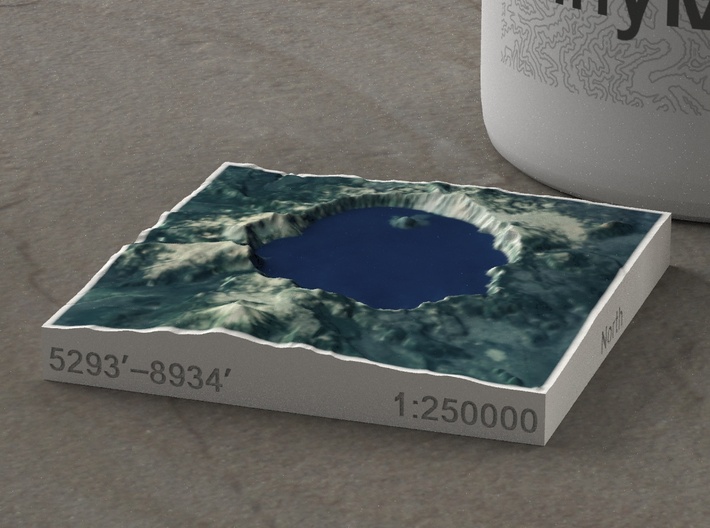
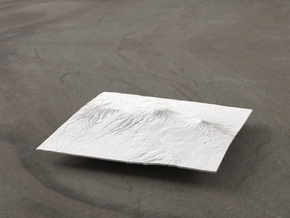
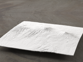
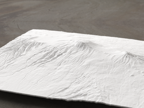
This model focuses on the caldera itself, containing the 1958-foot-deep Crater Lake and Wizard Island, a cinder cone that rises 763 feet above the lake's surface. Phantom Ship, a 400'-long island between Chaski Bay and Danger Bay, is easily visible on the larger models. Terrain features around the lake include The Watchman, Hillman Peak, Llao Rock with its steep cliffs dropping 2000' to the water, Mazama Rock, Roundtop, Cloudcap, Mount Scott (the highest peak in the area, and 2750' above the lake surface), Castle Rock, Kerr Notch and Valley, Dutton Cliff and Ridge, Applegate Peak, Eagle Crags, Garfield Peak, and Munson Ridge (atop which rest Rim Village and Crater Lake Lodge).
This model is a combination of large land area and recent high-resolution USGS mapping, and as such, even the largest models will show sub-millimeter details. This is what TinyMtn is all about: bringing you the absolute best landscape models available anywhere.
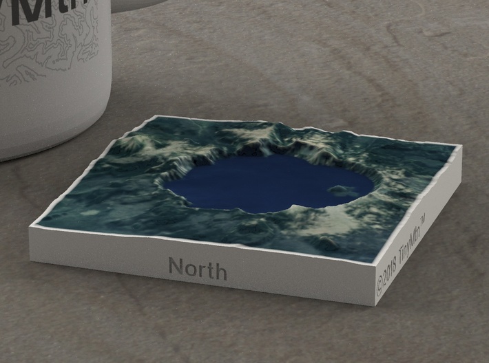
The Explorer series of TinyMtn models is designed to break our usual impression of mountains. We generally see mountains one at a time, from a distance, and from the ground. While all TinyMtn models give you a fresh perspective on any one peak, the Explorer series presents mountains in identical scale, and shifted up so that sea level is at the bottom of the base. Thus, when you set two Explorer models next to each other, you will immediately notice which is taller, which rises more from its base, which is more massive, and so on. Plus, all Explorer models come in full color, making them just that much more realistic.
Model scale is 1:250000
Model measures 2.5" x 2.5" x 0.43" (6.3 x 6.3 x 1.09 cm)
Original area is approximately 9.8 by 9.8 miles
Altitudes covered: 5293' to 8934'
There is no vertical exaggeration applied to this model. This is a true-to-life scale model of a real place.
Click here for more sizes.
Click here for other 1:250000 models in the Explorer series.
TinyMtn models are most affordable in the "Sandstone" and "White Natural Versatile Plastic" materials. This model is in "Sandstone," which is a glued gypsum material. When you receive the model it will be ready for display, though it may smell funny and need some time to air out. "Sandstone" models are much more brittle than "Versatile Plastic" models, but feel more like light stone. Do not soak it in water, though you can safely seal it with Polycrylic or a similar water-based clear spray sealant. Read more about this popular material here.
All TinyMtn models have hollow bottoms - this is to save on weight, and thus cost. Many larger models also have extra flanges on their undersides to increase rigidity and strength. To make the model more solid, you should feel free to carefully pour resin into the bottom cavity, or glue a properly-sized slab of wood or another material into it.
These models have been optimized for the above materials, and are not offered in other materials for strength or cost reasons. If you need one in another material, please tinymtnbiz@gmail.com and we'll do our best to fulfill your request.
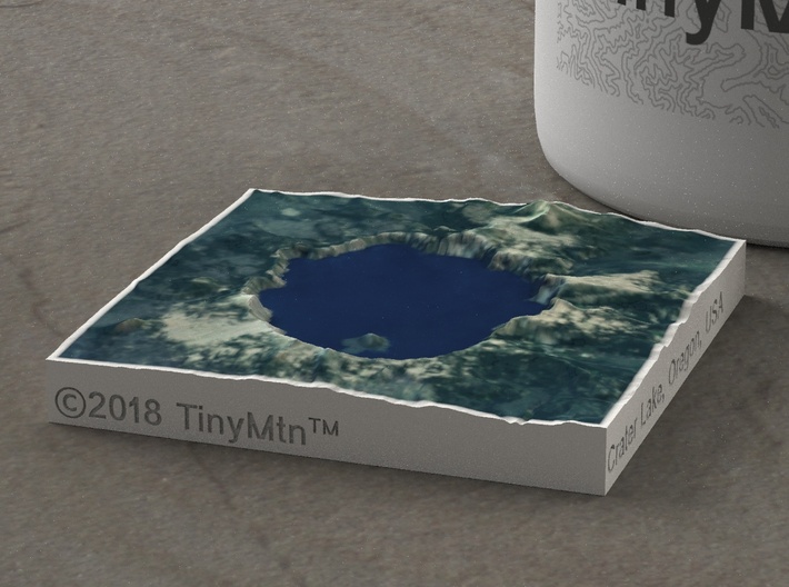
(C) 2018 TinyMtn (TM)
Model created using GDAL, NetPBM, Gmsh, Carve, MeshLab, and other custom software
Contains modified Copernicus Sentinel data from 2016
Copernicus Open Access Hub is https://scihub.copernicus.eu/dhus
Source of digital elevation and aerial orthoimagery data: U.S. Geological Survey
The USGS home page is https://www.usgs.gov/
This model focuses on the caldera itself, containing the 1958-foot-deep Crater Lake and Wizard Island, a cinder cone that rises 763 feet above the lake's surface. Phantom Ship, a 400'-long island between Chaski Bay and Danger Bay, is easily visible on the larger models. Terrain features around the lake include The Watchman, Hillman Peak, Llao Rock with its steep cliffs dropping 2000' to the water, Mazama Rock, Roundtop, Cloudcap, Mount Scott (the highest peak in the area, and 2750' above the lake surface), Castle Rock, Kerr Notch and Valley, Dutton Cliff and Ridge, Applegate Peak, Eagle Crags, Garfield Peak, and Munson Ridge (atop which rest Rim Village and Crater Lake Lodge).
This model is a combination of large land area and recent high-resolution USGS mapping, and as such, even the largest models will show sub-millimeter details. This is what TinyMtn is all about: bringing you the absolute best landscape models available anywhere.
The Explorer series of TinyMtn models is designed to break our usual impression of mountains. We generally see mountains one at a time, from a distance, and from the ground. While all TinyMtn models give you a fresh perspective on any one peak, the Explorer series presents mountains in identical scale, and shifted up so that sea level is at the bottom of the base. Thus, when you set two Explorer models next to each other, you will immediately notice which is taller, which rises more from its base, which is more massive, and so on. Plus, all Explorer models come in full color, making them just that much more realistic.
Model scale is 1:250000
Model measures 2.5" x 2.5" x 0.43" (6.3 x 6.3 x 1.09 cm)
Original area is approximately 9.8 by 9.8 miles
Altitudes covered: 5293' to 8934'
There is no vertical exaggeration applied to this model. This is a true-to-life scale model of a real place.
Click here for more sizes.
Click here for other 1:250000 models in the Explorer series.
TinyMtn models are most affordable in the "Sandstone" and "White Natural Versatile Plastic" materials. This model is in "Sandstone," which is a glued gypsum material. When you receive the model it will be ready for display, though it may smell funny and need some time to air out. "Sandstone" models are much more brittle than "Versatile Plastic" models, but feel more like light stone. Do not soak it in water, though you can safely seal it with Polycrylic or a similar water-based clear spray sealant. Read more about this popular material here.
All TinyMtn models have hollow bottoms - this is to save on weight, and thus cost. Many larger models also have extra flanges on their undersides to increase rigidity and strength. To make the model more solid, you should feel free to carefully pour resin into the bottom cavity, or glue a properly-sized slab of wood or another material into it.
These models have been optimized for the above materials, and are not offered in other materials for strength or cost reasons. If you need one in another material, please tinymtnbiz@gmail.com and we'll do our best to fulfill your request.
(C) 2018 TinyMtn (TM)
Model created using GDAL, NetPBM, Gmsh, Carve, MeshLab, and other custom software
Contains modified Copernicus Sentinel data from 2016
Copernicus Open Access Hub is https://scihub.copernicus.eu/dhus
Source of digital elevation and aerial orthoimagery data: U.S. Geological Survey
The USGS home page is https://www.usgs.gov/
Details
What's in the box:
Crater Lake, Oregon, USA, 1:250000 Explorer

Dimensions:
Success Rate:
First To try.
What's this?
Rating:
Mature audiences only.
